
Weather Related News
This site displays current Tornado, Wind and Hail activity reported to NOAA each day.
http://www.spc.noaa.gov/climo/reports/today.html
For the most current Tropical Atlantic updates,
National Hurricane Center Graphical Tropical Weather Outlooks
NHC Atlantic Outlook (Tue, 23 Apr 2024)The Atlantic hurricane season runs from June 1st through November 30th.
>> Read more
NHC Atlantic Wallet 1 - No current storm
No current storm in NHC Atlantic Wallet 1 (Thu, 25 Apr 2024)No current storm in NHC AT1 as of Thu, 25 Apr 2024 21:19:30 GMT
>> Read more
Atlantic Remnants Of Twenty-One Discussion Number 4
Atlantic Remnants Of Twenty-One Discussion Number 4 (Tue, 24 Oct 2023)000 WTNT41 KNHC 241457 TCDAT1 Remnants Of Twenty-One Discussion Number 4 NWS National Hurricane Center Miami FL AL212023 1100 AM EDT Tue Oct 24 2023 Satellite images show that the convection associated with Tropical Depression Twenty-One has weakened, and there are no signs of a well-defined surface center. Thus the system has dissipated over Nicaragua and the initial wind speed is set to 20 kt. The remnants of the system are forecast to continue west-northwestward to westward and cross over to the eastern Pacific by Wednesday. Heavy rainfall with flash and urban flooding remain the primary impacts even as the system dissipates. This is the last advisory from the National Hurricane Center on this system. KEY MESSAGES: 1. Heavy rains from the remnants of the depression will continue to impact portions of Nicaragua through Tuesday night with heavy rainfall spreading into Honduras during the day on Tuesday. This rainfall is likely to produce flash and urban flooding, along with possible mudslides in areas of higher terrain. FORECAST POSITIONS AND MAX WINDS INIT 24/1500Z 13.6N 84.8W 20 KT 25 MPH...REMNANTS OF 12H 25/0000Z...DISSIPATED $$ Forecaster Bucci
>> Read more
SPC Forecast Products
SPC Tornado Watch 134 (Thu, 25 Apr 2024)WW 134 TORNADO CO KS OK TX 252200Z - 260500Z
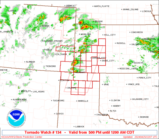 URGENT - IMMEDIATE BROADCAST REQUESTED
Tornado Watch Number 134
NWS Storm Prediction Center Norman OK
500 PM CDT Thu Apr 25 2024
The NWS Storm Prediction Center has issued a
* Tornado Watch for portions of
Southeastern Colorado
Western Kansas
Oklahoma Panhandle
Northern Texas Panhandle
* Effective this Thursday afternoon from 500 PM until Midnight
CDT.
* Primary threats include...
A few tornadoes and a couple intense tornadoes possible
Scattered large hail and isolated very large hail events to 3
inches in diameter likely
Scattered damaging winds and isolated significant gusts to 75
mph possible
SUMMARY...Isolated to scattered thunderstorms are expected to evolve
out of a belt of convection now building along a slow-moving
dryline, from near the CO/KS line southward into the northern TX
Panhandle. A few supercells may evolve out of this activity with an
early threat for large to very large hail and severe gusts. Tornado
potential would ramp up from late afternoon into evening with any
remaining supercell(s) as low-level shear increases.
The tornado watch area is approximately along and 50 statute miles
east and west of a line from 45 miles east southeast of Dalhart TX
to 55 miles north of Garden City KS. For a complete depiction of the
watch see the associated watch outline update (WOUS64 KWNS WOU4).
PRECAUTIONARY/PREPAREDNESS ACTIONS...
REMEMBER...A Tornado Watch means conditions are favorable for
tornadoes and severe thunderstorms in and close to the watch
area. Persons in these areas should be on the lookout for
threatening weather conditions and listen for later statements
and possible warnings.
&&
OTHER WATCH INFORMATION...CONTINUE...WW 133...
AVIATION...Tornadoes and a few severe thunderstorms with hail
surface and aloft to 3 inches. Extreme turbulence and surface wind
gusts to 65 knots. A few cumulonimbi with maximum tops to 550. Mean
storm motion vector 23025.
...Edwards
Read more
URGENT - IMMEDIATE BROADCAST REQUESTED
Tornado Watch Number 134
NWS Storm Prediction Center Norman OK
500 PM CDT Thu Apr 25 2024
The NWS Storm Prediction Center has issued a
* Tornado Watch for portions of
Southeastern Colorado
Western Kansas
Oklahoma Panhandle
Northern Texas Panhandle
* Effective this Thursday afternoon from 500 PM until Midnight
CDT.
* Primary threats include...
A few tornadoes and a couple intense tornadoes possible
Scattered large hail and isolated very large hail events to 3
inches in diameter likely
Scattered damaging winds and isolated significant gusts to 75
mph possible
SUMMARY...Isolated to scattered thunderstorms are expected to evolve
out of a belt of convection now building along a slow-moving
dryline, from near the CO/KS line southward into the northern TX
Panhandle. A few supercells may evolve out of this activity with an
early threat for large to very large hail and severe gusts. Tornado
potential would ramp up from late afternoon into evening with any
remaining supercell(s) as low-level shear increases.
The tornado watch area is approximately along and 50 statute miles
east and west of a line from 45 miles east southeast of Dalhart TX
to 55 miles north of Garden City KS. For a complete depiction of the
watch see the associated watch outline update (WOUS64 KWNS WOU4).
PRECAUTIONARY/PREPAREDNESS ACTIONS...
REMEMBER...A Tornado Watch means conditions are favorable for
tornadoes and severe thunderstorms in and close to the watch
area. Persons in these areas should be on the lookout for
threatening weather conditions and listen for later statements
and possible warnings.
&&
OTHER WATCH INFORMATION...CONTINUE...WW 133...
AVIATION...Tornadoes and a few severe thunderstorms with hail
surface and aloft to 3 inches. Extreme turbulence and surface wind
gusts to 65 knots. A few cumulonimbi with maximum tops to 550. Mean
storm motion vector 23025.
...Edwards
Read more
>> Read more
SPC Tornado Watch 133 (Thu, 25 Apr 2024)
WW 133 TORNADO CO KS NE 251955Z - 260300Z
 URGENT - IMMEDIATE BROADCAST REQUESTED
Tornado Watch Number 133
NWS Storm Prediction Center Norman OK
155 PM MDT Thu Apr 25 2024
The NWS Storm Prediction Center has issued a
* Tornado Watch for portions of
Northeast Colorado
Northwest Kansas
Southwest Nebraska
* Effective this Thursday afternoon and evening from 155 PM until
900 PM MDT.
* Primary threats include...
A few tornadoes likely with a couple intense tornadoes possible
Scattered large hail and isolated very large hail events to 3
inches in diameter likely
Scattered damaging winds likely with isolated significant gusts
to 75 mph possible
SUMMARY...Thunderstorms are expected to rapidly intensify this
afternoon, with a few supercell storms likely. Very large hail, a
few tornadoes, and damaging winds will all be possible with this
activity through the evening.
The tornado watch area is approximately along and 50 statute miles
north and south of a line from 55 miles northwest of Burlington CO
to 55 miles south southeast of Mccook NE. For a complete depiction
of the watch see the associated watch outline update (WOUS64 KWNS
WOU3).
PRECAUTIONARY/PREPAREDNESS ACTIONS...
REMEMBER...A Tornado Watch means conditions are favorable for
tornadoes and severe thunderstorms in and close to the watch
area. Persons in these areas should be on the lookout for
threatening weather conditions and listen for later statements
and possible warnings.
&&
AVIATION...Tornadoes and a few severe thunderstorms with hail
surface and aloft to 3 inches. Extreme turbulence and surface wind
gusts to 65 knots. A few cumulonimbi with maximum tops to 500. Mean
storm motion vector 26035.
...Hart
Read more
URGENT - IMMEDIATE BROADCAST REQUESTED
Tornado Watch Number 133
NWS Storm Prediction Center Norman OK
155 PM MDT Thu Apr 25 2024
The NWS Storm Prediction Center has issued a
* Tornado Watch for portions of
Northeast Colorado
Northwest Kansas
Southwest Nebraska
* Effective this Thursday afternoon and evening from 155 PM until
900 PM MDT.
* Primary threats include...
A few tornadoes likely with a couple intense tornadoes possible
Scattered large hail and isolated very large hail events to 3
inches in diameter likely
Scattered damaging winds likely with isolated significant gusts
to 75 mph possible
SUMMARY...Thunderstorms are expected to rapidly intensify this
afternoon, with a few supercell storms likely. Very large hail, a
few tornadoes, and damaging winds will all be possible with this
activity through the evening.
The tornado watch area is approximately along and 50 statute miles
north and south of a line from 55 miles northwest of Burlington CO
to 55 miles south southeast of Mccook NE. For a complete depiction
of the watch see the associated watch outline update (WOUS64 KWNS
WOU3).
PRECAUTIONARY/PREPAREDNESS ACTIONS...
REMEMBER...A Tornado Watch means conditions are favorable for
tornadoes and severe thunderstorms in and close to the watch
area. Persons in these areas should be on the lookout for
threatening weather conditions and listen for later statements
and possible warnings.
&&
AVIATION...Tornadoes and a few severe thunderstorms with hail
surface and aloft to 3 inches. Extreme turbulence and surface wind
gusts to 65 knots. A few cumulonimbi with maximum tops to 500. Mean
storm motion vector 26035.
...Hart
Read more
>> Read more
Claims Related News
News Archives - Claims Journal
Work Safety Group Releases List of ‘Dirty Dozen’ Employers (Thu, 25 Apr 2024)A retail giant, a space launch operation, a major food processor, the nation’s two biggest rideshare providers and a large healthcare system are among those entities marked as being among the most unsafe employers. The National Council for Occupational Safety …
>> Read more
‘It’s in the Mail’ Not Good Enough to Contest Connecticut Workers’ Comp Claim (Thu, 25 Apr 2024)
A Connecticut employer lost its right to contest a workers’ compensation claim because although it mailed its notice to the workers compensation board within the 28 day statutory period, board did not receive the notice by the 28th day. The …
>> Read more
Claims Management System Access
Client Services
 Independent Insurance Adjusters
- "Lost time is never found again"
- -- Dr. Benjamin Franklin
Discover the advantages of and benefits of contracting our Property Claims Adjusters, Commercial Claims Adjusters, Liability Claims Adjusters, Aviation Claims Adjusters, Catastrophe Claims Adjustersand other types of claims services offered by Accelerated Adjusting LLC.